The measurement question and its physical mechanism
What can an aerial reconstruction legitimately measure where a shoreline includes reflective or transparent water? This is a practical question for teams evaluating Online Photogrammetry Software, because the usefulness of a mapping product depends on the observations and decisions that support it.
Water can move, reflect sky and surrounding structures, and reveal submerged features through refraction. Those observations do not obey the same static opaque-surface assumptions as a road or bare ground patch.
An orthomosaic is a map representation assembled from photographic observations and geometric processing. Its continuous appearance can conceal differences in source time, viewing direction, surface support, and local visibility. Define the physical feature to be mapped and inspect it in the original imagery before judging a final pixel. Roof, canopy, ground, and water are different surfaces; a useful quality statement identifies which of them the imagery actually supports and where a two-dimensional representation becomes limiting.
Acquisition and input preparation
Plan exposure and flight timing to preserve the dry shore and stable adjacent objects. Record tide or water-level context where relevant, and avoid assuming that visible underwater texture yields uncorrected terrain elevations.
Evaluate the native raster, its mask, and the surface used to place image content. Compare screenshots only after matching display scale and color treatment. When an artifact appears, locate its source images and determine whether the mechanism is geometry, image selection, illumination, coverage, or export behavior. These causes can look similar in a browser preview yet require very different remedies. Preserve the accepted master so cartographic derivatives do not silently replace measurement evidence.
Illustrative worked example
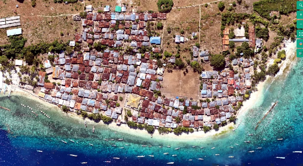
The following numbers are hypothetical planning inputs, not measured product results or an accuracy claim. Imagine a shoreline survey with 30 percent open water. If 90 percent of the dry land is well reconstructed but an automatic surface fill covers the water, the visual map might look nearly complete even though its measurement support differs sharply by surface. Report the dry-land coverage separately and define whether the shoreline refers to a visible wet edge, a mapped vegetation edge, or another physical criterion. A 40 cm water-level difference between sessions can move the visible edge on a gently sloping beach; the horizontal movement depends on the actual slope. Do not convert that edge movement into erosion without appropriate timing, level, and terrain evidence. Mark water and submerged observations with their distinct limitations.
What the example means for this topic
The boundary between valid land and problematic water should be inspected rather than generated solely from color. Wet sand, dark pavement, and shaded vegetation can resemble water in imagery. Use physical context and source views, and preserve uncertainty at ambiguous edges. A practical shoreline map needs a clear definition of the mapped feature and acquisition timing, not simply a crisp-looking blue-to-brown seam.
A reproducible processing experiment
Use a separate quality mask for water and inspect whether unstable water matches distort nearby land. Evaluate shoreline position using the intended physical definition and the actual image time.
Make the comparison reproducible before changing the workflow. Freeze a working copy of the image inventory and give the baseline a clear run identifier. Save the relevant camera configuration, image preparation steps, processing settings, requested outputs, and comparison extent. Select inspection regions that include the mechanism under investigation as well as a stable control region. A useful control is a surface expected to remain unaffected by the proposed change, because it can reveal whether an apparent local improvement introduces a broader adverse effect elsewhere in the block.
Change one justified factor at a time whenever practical. Use the same physical features and independent reference observations in the baseline and candidate. Compare on their common valid area, then report any difference in total supported coverage separately. Keep display zoom, color stretch, and viewing direction consistent when screenshots are part of the evidence. Record resource use and failures as outcomes too: a configuration that slightly improves detail but repeatedly exceeds available memory may not be operationally suitable for the agreed delivery.
Write the decision rule before examining the most attractive output. For example, the candidate may need to retain all critical features, reduce an identified systematic pattern, and avoid a new coverage gap. The actual thresholds must come from the project purpose and reference quality, not from the illustrative numbers in this article. Preserve both the accepted and rejected experiment records long enough to explain the choice. This is especially valuable when a later operator needs to repeat the workflow under different light, camera, or software conditions.
Diagnosing the result
A glittering surface may generate numerous inconsistent features. A smooth water mesh can be an interpolation, while visible submerged objects may be displaced by refraction.
Uncertainty and independent quality checks
Separate internal agreement from independent product validation. Observations used to fit camera positions, calibration, or a surface cannot by themselves establish external accuracy. Reserve suitable checks when the measurement task requires them and document the uncertainty of those checks. The reference should identify the same physical feature that appears in the map or model; a precise survey of an ambiguous edge can still produce an uncertain comparison. Inspect signed differences and spatial patterns, because a single average can hide a broad bias or one consequential local failure.
Keep uncertainty statements tied to the quantity being used. Horizontal location, height, distance, surface completeness, and visual interpretability are not interchangeable. Pixel spacing is a sampling property, and point density is a representation property; neither alone specifies the error of a derived measurement. Do not convert a camera-model residual directly into a universal ground-accuracy claim. If evidence is limited to a pilot region or one surface class, state that scope and avoid extending the conclusion to untested materials, distant boundaries, or hidden surfaces.
Unknown areas should remain identifiable. A smooth mesh, filled raster, balanced image, or sharp texture can be useful for communication while containing information inferred from its surroundings. Retain masks or an edit record for consequential inferred regions, and choose additional observations when the missing evidence affects the decision. Where a formal specification applies, use its required sampling and reporting procedure rather than treating this explanatory workflow as certification. The practical goal is a defensible statement about supported use, with enough evidence for another team to assess its limits.
The practical decision and delivery record
Deliver reliable land coverage with clear water limitations, and use an appropriate water-survey method when submerged elevation or a legally defined shoreline is required.
The accepted handoff should contain a concise inventory of the authoritative outputs and the evidence needed to interpret them. Include the acquisition interval, surface definitions, relevant units and reference information, coverage boundary, input manifest, accepted configuration, and material quality findings. Open the downloaded files in an appropriate independent reader and inspect difficult regions as well as easy ones. Preserve an unambiguous version identifier so a recipient does not accidentally measure an earlier experimental export that happens to have a similar filename.
Translate each remaining limitation into a practical consequence. State which feature, area, or use it affects and whether the appropriate next step is another view, a complementary measurement, a different representation, or a narrower interpretation. Avoid a generic high-quality label when one critical region remains unsupported. A short explanation attached to the relevant location is more useful than an impressive global statistic that leaves users to discover the exception after making a consequential decision.
Testing a suitable cloud workflow
A useful evaluation of Online Photogrammetry Software starts with a known question and a representative image collection. DroneCollab can be considered for orthomosaic, point-cloud, DSM/DTM, and textured three-dimensional outputs, including projects using GNSS/PPK workflows. Use the pilot to inspect the surfaces and file types the recipient will actually need. Keep the acceptance checks independent of the product choice, and retain the original observations so a convenient cloud workflow remains connected to a verifiable measurement record.